
Montant total (1 article articles) :
Destination de la commande :

title compass rose (7 résultats)
Passer aux résultats principaux de la recherche
Type d'article
- Tous les types de produits
- Livres (4)
- Magazines & Périodiques
- Bandes dessinées
- Partitions de musique
- Art, Affiches et Gravures
- Photographies
- Cartes (3)
- Manuscrits & Papiers anciens
Etat
Reliure
- Toutes
- Couverture rigide
- Couverture souple (2)
Particularités
Livraison gratuite
- Frais de port gratuits USA
Pays
Evaluation du vendeur
-
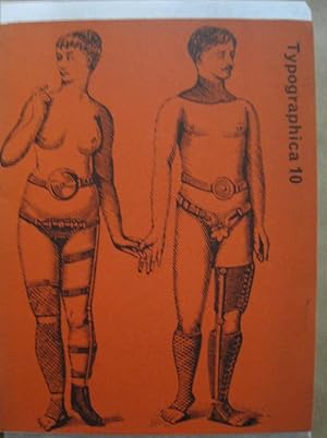
Typographica 10, December 1964. (= Typographica New Series): Allen Hutt - Newspaper seals / W. E. May - The compass rose / Charles Hasler - The emergence of the printer's stock block / Robert Brownjohn - Sex and typography (includes illustrations of his James Bond film From Russia with Love title sequences.
Edité par London, Lund Humphries, 1964. First edition / Erste und einzige Ausgabe., 1964
Vendeur : Antiquariat Carl Wegner, Berlin, B, Allemagne
Membre d'association : GIAQ
Evaluation du vendeur :

Edition originale
Softcover. 4°. Illustrated original brochure in the reddish, illustrated original cover. Only the dust jacket slightly soiled. 58 (+6) pages with over 250 illustrations. Scrutinized page by page. Really good copy. With the exception of the dust jacket, very clean, firm in the binding, no markings. -- 4°. Illustrierte Original-Broschur im rötlichen, illustrierten Original-Umschlag. Nur der Schutzumschlag leicht angeschmutzt. 58 (+6) Seiten mit über 250 Illustrationen. Seite für Seite genau überprüft. Richtig gutes Exemplar. Mit Ausnahme des Schutzumschlages sehr schön sauber, fest in der Bindung, keine Anstreichungen. -- Bitte Portokosten außerhalb EU erfragen! / Please ask for postage costs outside EU! / S ' il vous plait demander des frais de port en dehors de l ' UE! -- Genießen Sie den Sommer und bestellen Sie ein Buch bei uns! FL0495-317829.
-
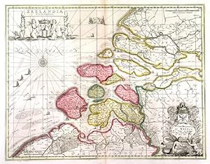
'ZEELANDIA COMITATUS'. Map of Zeeland, the southwestern part of The Netherlands. Figurative title and dedication cartouches, compass rose, sailing ships. Published after the map by Joannes Janssonius by
Edité par Moses Pitt ca. 1681, 1681
Carte
38x49cm. The map in full original colour. Excellent condition.
-
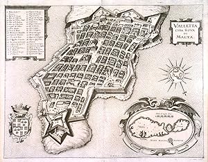
'VALLETTA CITTA NOVA DI MALTA'. Half birds-eye view of Valletta with title cartouche, table of explanations, large cartouche with map of Malta and Gozo, compass rose with inset map of Italy and coat of arms. Engraved by Merian and published by
Edité par Johann Ludwig Gottfried in Frankfurt 1646, 1646
Carte
27x35cm. Excellent condition. Uncoloured as originally published.
-
Particuliere de l'Amerique Septentrionale, ou sont Compris le Detroit de Davids, le Detroit de Hudson, &c. . Amsterdam, 1700. Printed on thick paper, good condition, coloured by a contemporary hand. MORTIER, Pierre (1661-1711). Carte Particuliere de l'Amerique Septentrionale, ou sont Compris le Detroit de Davids, le Detroit de Hudson, &c. . Amsterdam, 1700. Engraved map on two jointed sheets, showing parts of northeast Canada, the mouth of the St. Lawrence, Hudson's Bay to Baffin's Bay and eastward to Greenland and Iceland, fully colored by a contemporary hand, image 592 x 827 mm. Compass roses and rhumb lines on the sea. Large, beautifully colored map from the Neptune Francoise. According to its title, many of the charts were produced
Date d'édition : 1700
Vendeur : Hammelburger Antiquariat, Hammelburg, Allemagne
Evaluation du vendeur :

Carte
Kein Einband. Etat : Gut. Particuliere de l'Amerique Septentrionale, ou sont Compris le Detroit de Davids, le Detroit de Hudson, &c. . Amsterdam, 1700. Printed on thick paper, good condition, coloured by a contemporary hand. MORTIER, Pierre (1661-1711). Carte Particuliere de l'Amerique Septentrionale, ou sont Compris le Detroit de Davids, le Detroit de Hudson, &c. . Amsterdam, 1700. Engraved map on two jointed sheets, showing parts of northeast Canada, the mouth of the St. Lawrence, Hudson's Bay to Baffin's Bay and eastward to Greenland and Iceland, fully colored by a contemporary hand, image 592 x 827 mm. Compass roses and rhumb lines on the sea. Large, beautifully colored map from the Neptune Francoise. According to its title, many of the charts were produced from the manuscripts drawn by N.P. d'Ablancourt, a French diplomat in Lisbon, from the Portuguese archives. Burden II, 763.
-
'T hooghe heymraedtschap vanden lande van Woerden.[Amsterdam, Hendrik de Leth], 1740. Wall map of the water district Woerden (South Holland) in 9 large loose untrimmed sheets (each 48 x 67 cm), with the title in a banderole across the head of three sheets, information about the 14th-century charters in a cartouche, a list of city and town officials in 1739 on a plinth, a compass rose, and a scale of Rijnland rods.
Vendeur : Antiquariaat FORUM BV, Houten, Pays-Bas
Membre d'association : ILAB NVVA
Evaluation du vendeur :
A large wall map of the water district Woerden in the province of South Holland (on the border of the province of Utrecht), including the cities of Woerden, Oudewater and Montfoort, as well as many smaller towns (including Bodegraven) and the surrounding polders. Altogether it covers a region smaller than 20 by 20 kilometres at a scale of 1:17,000 (north above and to the right) and if assembled it would have a map image of 122 by 152 cm. It shows the fortifications and principal buildings of the three main cities, other forts and (outside the three main cities) every house, church and windmill. It gives the names of the individual polders (with their boundaries), the roads, waterways and dikes, and some wind mills and houses. The map was first engraved and printed in 1670 and 1671 by the Vingboons brothers, draftsmen, engravers and printers. The present is the sixth printing by Hendrik the Leth, who published the maps with and without the coats of arms, which were updated with most printings. The present set is an issue without the coats of arms.A few minor stains and some negligible inks smudges, and a piece cut off from the left margin of sheet 6 (not reaching the plate), otherwise in very good condition, and wholly untrimmed.l Donkersloot-de Vrij 764, 6th of 8 printings (6 copies).
-
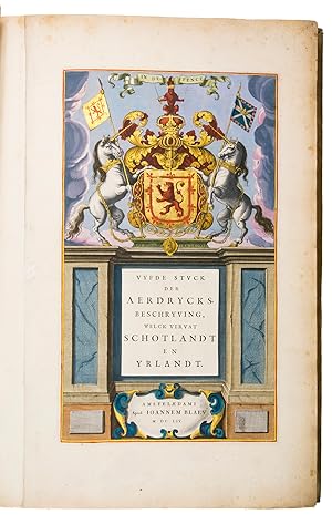
Vyfde stuck der aerdrycksbeschryving, welck vervat Schotlandt en Yrlandt.Amsterdam, Joan Blaeu, 1654. Atlas folio (57.5 x 39.5 cm). With engraved architectural title-page with the arms of Scotland filling the top half, elaborately crested, supported by unicorns with flags and still with the old Stuart royalist mottos, and 55 engraved maps (54 double-page and 1 of the Irish County Caterlogh, full-page), often richly adorned with additional cartouches with regional scenes, but most often with coats of arms from the region. Numerous woodcut tailpieces and decorated initial letters. The title-page and all maps, including the cartouches, scenes and coats of arms, beautifully coloured by hand and highlighted with gold. All maps in their first states, without added ships or compass roses. 17th-century Dutch gold-tooled vellum.
Vendeur : ASHER Rare Books, T Goy Houten, Pays-Bas
Membre d'association : ILAB NVVA
Evaluation du vendeur :
[8], 189, [1 blank], 70, [1, 1 blank] pp.First edition, in Dutch, of the first national atlas of Scotland, far more accurate than any previously published, complete with the atlas of Ireland, the whole beautifully executed by Blaeu's printing office and with the engraved title-page, maps, and the cartouches, pictorial scenes and coats of arms in the maps coloured by a contemporary hand and highlighted with gold. The maps are coloured in outline, but with cities, forests, mountain ranges, etc. also coloured. It was published both separately and (as in the present copy) as the 5th volume of the 9-volume Dutch edition of Blaeu's Atlas major or Grooten atlas.Willem Jansz. Blaeu initiated work on a Scottish atlas ca. 1631, based at first on manuscript maps made by Timothy Pont ca. 1596-1600, but it was set aside. Blaeu died in 1638 and his son Joan returned to the project, gaining the patronage of King Charles I of England in 1641. King Charles enlisted the Scottish geographer Robert Gordon, near Aberdeen, who carried out new surveys to correct and supplement Pont's maps. The English Civil War delayed work further. King Charles was beheaded in 1649, so when the atlas finally appeared in 1654 (in Latin, French, Dutch, German and Spanish editions) it bore a privilege from (among others) Oliver Cromwell. It was the second volume to be completed (after France) of what was to become Blaeu's most famous atlas ("the greatest and finest atlas ever published": De la Fontaine Verwey), the Dutch edition completed in 1665. The title in the letterpress slip on the engraved title-page and the volume number on the spine show that the present copy was included as part of the Grooten atlas, but both the states of the maps and the variant readings in the letterpress text show the versions noted by Van der Krogt in the earliest copies, issued separately, confirming the title-page date 1654.The main text and preliminaries are set in four large roman types cut by Nicolaes Briot, the largest accompanied by Christoffel van Dijck's italic.In good condition, with a few leaves browned, a few creased, and occasional minor water stains or foxing. The first atlas of Scotland and Ireland, splendidly produced by Joan Blaeu.l Koeman & V.d. Krogt 2:621.5 (2:421Qa with different title-slip); cf: H. de la Fontaine Verwey, "De glorie van de Blaeu-Atlas", in: Uit de Wereld van het Boek III, pp. 195 ff.
-
[engraved title-page:] A plan of mathematical learning taught in the Royal Academy Portsmouth performed by [in pencil: Charles Sotheby] a student there.[Portsmouth], "177 " [recté 1795-1798]. 2 volumes. Imperial 4to (37.5 x 27 cm). Manuscript school exercises with a pre-printed engraved title-page with a blank space for the student to add his name, with 4 full-page and 1 larger folding nautical charts (some partly in colour), 7 full-page fortification plans (in black ink with 1 to 3 colours), 4 full-page astronomical diagrams (2 also with yellow), a full-page compass rose, 23 pen and ink wash views in the text (9 x 15 cm to 12.5 x 22 cm, 1 also with blue washes), and numerous other diagrams (including maps in the surveying section) and some illustrations in the text. Near contemporary (ca. 1803) blind- and gold-tooled half calf, blue sprinkled edges.
Vendeur : Antiquariaat FORUM BV, Houten, Pays-Bas
Membre d'association : ILAB NVVA
Evaluation du vendeur :
engraved title-page + "229" [= 228]; 230-493, [2 blank] pp., with pp. 229 and 493 blank excepting the page numbers.Exercises in mathematics, navigation, fortification, surveying, mechanics, etc., at the Royal Naval Academy in Portsmouth, finely executed by the future Admiral Charles Sotheby (1782-1814) when he studied there in the years 1795 to 1798 (probably ages 13 to 15). The large folding nautical chart of the North Atlantic shows the North American coast from Newfoundland to Cape Cod, the Caribbean and Atlantic islands and the coasts of West Africa and western Europe, while the full-page one includes the coasts of Greenland, Iceland, western Europe, West Africa, the Atlantic islands and a sand bank off Newfoundland. The other nautical charts show Christmas Island (off the coast of Java, though the form differs), Palmerston Island (in the South Pacific) and Table Bay (at Cape Town, South Africa) in great detail. The pages have been numbered as a whole, with a single series covering both volumes, and mostly also section by section with the following number of pages: arithmetic 56, geometry 48, plane trigonometry 18, the description and use of the terrestrial globe 5, geography 12, chronology 10, navigation 17 & 29, spherics 28, astronomy 34, latitude 13, longitude [33], days works [= journal keeping] [22], marine surveying [31], fortification [29], gunnery [22] and mechanics [19].Charles Sotheby (1782-1854), entered the Royal Naval Academy at Portsmouth on 5 September 1795 and studied there until he began his service in the British navy on 31 March 1798, seeing duty at the Battle of the Nile in that year. He commanded a ship by 1809 and rose steadily through the ranks until he became Rear-Admiral in 1848. The academy was restricted to sons of noblemen and gentlemen and was intended to train officers for naval command.The present exercise book not only shows Sotheby's high level of skill and knowledge at an early age, it also provides a very clear and detailed picture of the training of British naval officers in the 1790s, as Napoleon began making his earliest plans to invade England.Each volume with the engraved bookplate of Charles Sotheby, with the rampant talbot crest from the Sotheby coat of arms, and also with the bookplate of the Dutch cartographic historian Cornelius Koeman (1918-2006). In very good condition, with only a small chip in one leaf and a tattered fore-edge in a few others. The bindings are rubbed and the spines worn, with a crack in the front hinge of vol. II, but the tooling remains clear. A detailed and fascinating picture of the teenage studies at the Royal Naval Academy in Portsmouth.

![Image du vendeur pour 'T hooghe heymraedtschap vanden lande van Woerden.[Amsterdam, Hendrik de Leth], 1740. Wall map of the water district Woerden (South Holland) in 9 large loose untrimmed sheets (each 48 x 67 cm), with the title in a banderole across the head of three sheets, information about the 14th-century charters in a cartouche, a list of city and town officials in 1739 on a plinth, a compass rose, and a scale of Rijnland rods. mis en vente par Antiquariaat FORUM BV](https://pictures.abebooks.com/inventory/md/md22675703201.jpg)
![Image du vendeur pour [engraved title-page:] A plan of mathematical learning taught in the Royal Academy Portsmouth performed by [in pencil: Charles Sotheby] a student there.[Portsmouth], "177 " [recté 1795-1798]. 2 volumes. Imperial 4to (37.5 x 27 cm). Manuscript school exercises with a pre-printed engraved title-page with a blank space for the student to add his name, with 4 full-page and 1 larger folding nautical charts (some partly in colour), 7 full-page fortification plans (in black ink with 1 to 3 colours), 4 full-page astronomical diagrams (2 also with yellow), a full-page compass rose, 23 pen and ink wash views in the text (9 x 15 cm to 12.5 x 22 cm, 1 also with blue washes), and numerous other diagrams (including maps in the surveying section) and some illustrations in the text. Near contemporary (ca. 1803) blind- and gold-tooled half calf, blue sprinkled edges. mis en vente par Antiquariaat FORUM BV](https://pictures.abebooks.com/inventory/md/md30580469936.jpg)